Rita Update
From the Petroleum viewpoint:
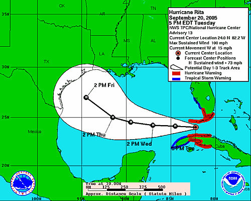
The worst tracks are those which put landfall between Freeport and Sabine Pass Texas. There are 3 tracks that cross just offshore of the TX/LA border. Those 3 tracks all let the storm hit more rigs and platforms than the tracks that have landfall farther south. The big concentrations of platforms are in the West Cameron, High Island, Galveston, and Matagorda Island offshore areas. Mustang Island and North/South Padre Island offshore areas are less crowded with production. If you want to know what these areas look like and where they are geographically, try the MMS website. They instituted the block layout, naming and leasing stuff. Landfall just east of Houston's center will be right up refinery alley. Another bad spot is right up through Port Arthur and Beaumont - another big refining center.All those little dots are oil/gas rigs:

Chart here
posted by greyhair @ 2:40 PM
1 comments
![]()
![]()
1 Comments:
Gosh, I hope Crawford stays safe!
Post a Comment
<< Home